Posts tagged with "OBIS SEAMAP"

Habitat-based cetacean density models for the U.S. Atlantic and Gulf of Mexico
Cetaceans are protected worldwide but vulnerable to incidental harm from an expanding array of human activities at sea. Managing potential hazards to these highly-mobile populations increasingly requires a detailed understanding of their seasonal distributions and habitats. Pursuant to the urgent need for this knowledge for the U.S. Atlantic and Gulf of Mexico, we integrated 23 years of aerial and shipboard cetacean surveys, linked them to environmental covariates obtained from remote sensing and ocean models, and built habitat-based density models for 26 species and 3 multi-species guilds using distance sampling methodology.
Use cases tagged with "OBIS SEAMAP"
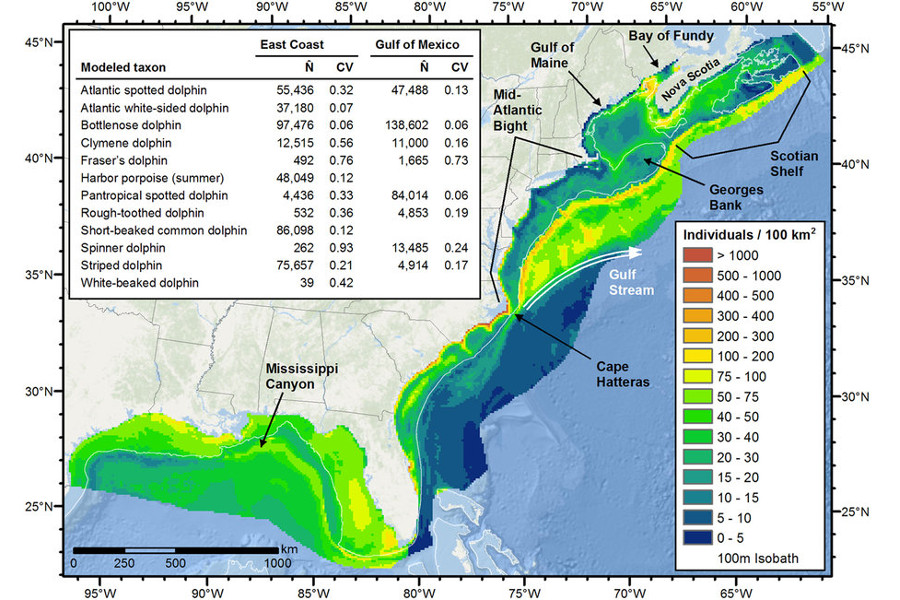
Habitat-based cetacean density models for the U.S. Atlantic and Gulf of Mexico
Cetaceans are protected worldwide but vulnerable to incidental harm from an expanding array of human activities at sea. Managing potential hazards to these highly-mobile populations increasingly requires a detailed understanding of their seasonal distributions and habitats. Pursuant to the urgent need for this knowledge for the U.S. Atlantic and Gulf of Mexico, we integrated 23 years of aerial and shipboard cetacean surveys, linked them to environmental covariates obtained from remote sensing and ocean models, and built habitat-based density models for 26 species and 3 multi-species guilds using distance sampling methodology.